\n

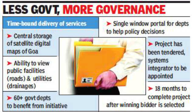
The e-governance portal<\/a> will collate and provide over 60 government departments with access to GIS (geographic information system) spatial layers that will come in handy while taking key policy<\/a> decisions.
Government sources said that the initiative will provide various government departments with a single window portal<\/a>. The departments will be able to access detailed GIS map for the entire state which will be developed using satellite imagery and available information. “The satellite image will be digitized to prepare a base map by digitizing all the features and attributes available to the public such as roads, bridges, railway tracks, parks, gardens, stadiums, traffic squares and water bodies (rivers, lakes, ponds, drainages, canals),” a government official said.
The e-governance portal will also collect information about utilities such as street lighting, water supply lines, sewerage network, waste-water, telecom, electricity, gas and storm water drain from the relevant departments. This data will be added as a layer on top of the satellite imagery.
The department of information and technology has already tendered the project. “It is envisaged to provide a robust and reliable decision support system to departments, local bodies, corporations and boards by integrating the GIS data and e-governance system,” the government source said.
<\/body>","next_sibling":[{"msid":65419439,"title":"China Unicom H1 profit rises 145 percent, beats estimate","entity_type":"ARTICLE","link":"\/news\/china-unicom-h1-profit-rises-145-percent-beats-estimate\/65419439","category_name":null,"category_name_seo":"telecomnews"}],"related_content":[{"msid":"65418272","title":"2","entity_type":"IMAGES","seopath":"city\/goa\/govt-to-embark-on-ambitious-plan-of-developing-detailed-digital-map-of-goa\/2","category_name":"Government to embark on ambitious plan of developing detailed digital map of Goa","synopsis":"Manohar Parrikar government plans to create a centralized repository of digital maps. ","thumb":"https:\/\/etimg.etb2bimg.com\/thumb\/img-size-83672\/65418272.cms?width=150&height=112","link":"\/image\/city\/goa\/govt-to-embark-on-ambitious-plan-of-developing-detailed-digital-map-of-goa\/2\/65418272"}],"msid":65420662,"entity_type":"ARTICLE","title":"Government to embark on ambitious plan of developing detailed digital map of Goa","synopsis":false,"titleseo":"telecomnews\/government-to-embark-on-ambitious-plan-of-developing-detailed-digital-map-of-goa","status":"ACTIVE","authors":[],"Alttitle":{"minfo":""},"artag":"TNN","artdate":"2018-08-16 11:10:24","lastupd":"2018-08-16 11:10:24","breadcrumbTags":["digital map of Goa","panaji","manohar parrikar","Portal","Government to embark on ambitious plan","policy"],"secinfo":{"seolocation":"telecomnews\/government-to-embark-on-ambitious-plan-of-developing-detailed-digital-map-of-goa"}}" data-authors="[" "]" data-category-name="" data-category_id="" data-date="2018-08-16" data-index="article_1">
PANAJI:在一个雄心勃勃的走向电子政务和有时限的交付服务,马诺Parrikar政府计划创建一个集中的存储库的数字地图。

的电子政务门户网站将核对并提供60多个政府部门提供GIS(地理信息系统)空间层,将派上用场而带钥匙吗政策决策。
政府消息人士表示,该计划将为各政府部门提供一个窗口门户网站。部门将能够访问整个州的详细GIS地图将使用卫星图像开发和可用的信息。“卫星图像将数字化准备基本地图数字化公共可用的所有特性和属性如道路、桥梁、铁路、公园、花园、体育场馆、交通广场和水体(河流、湖泊、池塘、流域、运河),”一位政府官员说。
电子政务门户网站也收集信息工具如街道照明、供水线路、排水网络,能源,电信、电力、天然气和雨水排水的有关部门。这些数据将被添加作为一个层上的卫星图像。
信息和技术部门已经递交了这个项目。“这是设想提供健壮和可靠的决策支持系统部门,当地机构,公司和董事会通过集成GIS数据和电子政务系统中,“政府消息人士称。

评论
现在评论 阅读评论(1)所有评论
找到这个评论进攻?
下面选择你的理由并单击submit按钮。这将提醒我们的版主采取行动